Climate zones are regions with consistent long-term temperature and precipitation patterns, driven mainly by latitude, elevation, and distance from oceans — the widely used Koppen system sorts the whole planet into five main groups.
Reading time
— 4 min
Updated
— Sep 24, 2026
Fact-reviewed
— Aug 17, 2026
Key Takeaways
Key Takeaways
1Climate zones are defined by long-term temperature and precipitation patterns, not by political borders or even always by latitude alone.
2The Koppen system, the most widely used climate classification, sorts the world into five main groups: tropical, dry, temperate, continental, and polar.
3Mountains and oceans can override latitude entirely — a coastal city and an inland city at the same latitude can have completely different climates.
The concept
A climate zone is a region that shares a similar long-term weather pattern — how hot or cold it typically gets, and how much rain or snow it typically receives across the year. Climate is different from day-to-day weather: a desert can have a rainy day, but its climate is still classified as dry because that's the long-term pattern.
Once you know climate depends on more than just how close a place is to the equator, some genuinely surprising real-world patterns start making sense.
Quick check
Seattle and a city at the same latitude in the middle of a continent often have milder winters and cooler summers than the inland city. What's the main reason?
Worked examples
Example 1: The five Koppen groups at a glance (baseline case)
Tropical (A) climates, found near the equator in places like the Amazon and Southeast Asia, stay warm year-round with high rainfall. Dry (B) climates, covering roughly a third of Earth's land — the Sahara, Australian Outback, and American Southwest among them — get very little precipitation regardless of temperature. Temperate (C) climates, like the Mediterranean or the U.S. Southeast, have mild winters and warm summers. Continental (D) climates, common across the northern U.S., Canada, and much of Russia, swing between cold winters and warm summers. Polar (E) climates, at the poles and high mountains, stay cold year-round.
Example 2: The Atacama Desert, a rain-shadow extreme (edge case)
Chile's Atacama Desert is one of the driest places on Earth, with some weather stations recording no measurable rainfall for decades. It sits in the rain shadow of the Andes to the east, while a cold ocean current offshore (the Humboldt Current) suppresses evaporation and rainfall from the Pacific side too — a case where two separate dry-climate mechanisms stack on top of each other, producing an extreme rarely matched anywhere else on the planet.
Example 3: Why climate classification matters for agriculture (real-world case)
Farmers, insurers, and governments use climate zone data (often a related system called USDA hardiness zones, itself derived from similar principles) to decide what crops will realistically survive in a given region and to price agricultural insurance. Planting a tropical crop in a continental climate zone isn't just risky — it's usually a guaranteed failure, because the plant's water and temperature requirements simply don't match the region's actual long-term pattern, no matter how good a single season's weather happens to be.
How it works (visual)
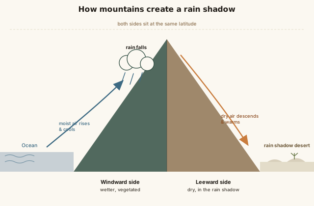
How elevation and rain shadows override latitude
Notice both sides of the mountain are at the same latitude and receive the same sunlight angle — the dramatic difference in climate is caused entirely by the mountain intercepting moisture on one side.
Common mistakes
Common Mistakes
✕
Assuming latitude alone determines climate.
→ Factor in elevation, ocean proximity, and mountain rain shadows — any of these can override the 'expected' climate for a given latitude.
✕
Confusing weather (short-term) with climate (long-term pattern).
→ A single hot day doesn't change a region's climate classification, and a single cold snap doesn't disprove a warming climate trend — climate is measured over decades.
✕
Assuming deserts are always hot.
→ The Koppen 'dry' category includes cold deserts too — Antarctica is technically the driest continent on Earth by precipitation, despite being covered in ice, not sand.
Common misconception
“Deserts are defined by sand and heat.”
Deserts are defined by low precipitation, not temperature or surface material. Antarctica receives so little snowfall that it qualifies as a desert by precipitation standards, despite being the coldest place on Earth. The Gobi Desert in Mongolia gets genuinely cold winters. What every desert shares is aridity, not a specific temperature or a sandy landscape.
Try it yourself
Estimate temperature drop from elevation gain
Estimated temperature at that elevation (°C)17
What to do next
What to do next
Look up your region's Koppen climate classification — it's a fast way to understand what actually grows well locally and why.
Next time you compare a coastal and inland city at the same latitude, check their average seasonal temperature swings — the ocean-moderation effect is usually visible immediately.
If you live near mountains, notice which side tends to be greener and which side tends to be drier — that's the rain shadow effect in action.
FAQ
FAQ
Related terms
Related terms
Koppen climate classification
A widely used system, developed by climatologist Wladimir Koppen, that sorts world climates into five main groups (and many subtypes) based on temperature and precipitation patterns.
Tropical zone
The climate belt roughly between the Tropic of Cancer and Tropic of Capricorn, generally warm year-round with high rainfall in many regions.
Rain shadow
A dry region on the leeward (downwind) side of a mountain range, where moist air has already dropped most of its rain on the windward side before crossing.
Microclimate
A small area with climate conditions noticeably different from its immediate surroundings, often caused by elevation, water bodies, or urban heat.
This entry was researched from public sources and drafted with AI-assisted tools, then edited — errors are still possible. Spot one, or want a topic covered? Read our disclaimer.
 KnowThis