 KnowThis
Key Takeaways
Key Takeaways
- 1"Seven continents" is the model most commonly taught, but it's a convention — geologists studying crust, not culture, would draw the lines differently.
- 2All of Earth's oceans are actually one connected body of water; the five named oceans are regions of that single ocean, divided by convention at continental coastlines and, in the Southern Ocean's case, by a current.
- 3Continents aren't static — they're riding on tectonic plates that have been rearranging Earth's surface for billions of years and are still moving today, just too slowly to notice day to day.
The concept
Understanding why the count is fuzzy makes the next part easier: continents and oceans aren't fixed shapes handed down from history, they're the current snapshot of a process that's still running.
Why do some countries teach a six-continent model that merges Europe and Asia into 'Eurasia'?
Worked examples
Example 1: Counting continents by area (baseline case)
Example 2: What happens if you switch to the six-continent model (edge case)
Example 3: Why the ocean count matters in practice (real-world case)
How it works (visual)
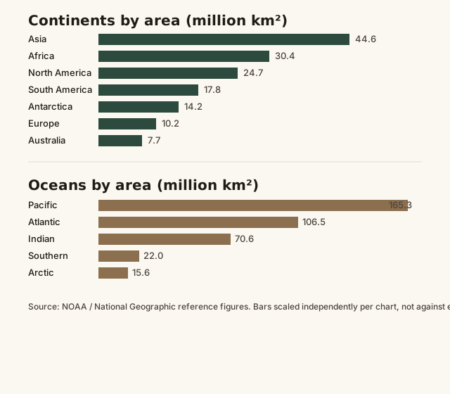
Notice the two charts aren't remotely proportional to each other — the Pacific Ocean alone, at roughly 165 million km², is bigger than all seven continents combined. Oceans cover about 71% of Earth's surface; land is very much the minority.
Common mistakes
Common Mistakes
Assuming 'seven continents' is a scientific fact rather than the most common convention.
→ Say 'the seven-continent model' when precision matters — geologists and some countries use different counts, and both are legitimate.
Treating oceans as separate bodies of water like separate lakes.
→ Remember all oceans are physically connected — the divisions are geographic conventions drawn at coastlines and currents, not walls of water.
Assuming continent shapes and positions are permanent.
→ Continents move a few centimeters a year via plate tectonics — roughly the speed fingernails grow — which adds up to enormous change over geological time.
Common misconception
“Australia is 'just an island,' not a real continent.”
Size is the only reason this feels intuitive, and it's not the deciding factor. Australia sits on its own continental crust and tectonic plate, distinct from the surrounding ocean floor, which is exactly the geological criterion that makes something a continent rather than an island — Greenland, by contrast, despite being larger than Australia in raw area, sits on the North American plate and is classified as the world's largest island, not a continent.
Try it yourself
What to do next
What to do next
- Next time you see a map, check whether it uses the four-, six-, or seven-continent model — the projection and the continent count both say something about who made the map.
- Look up which tectonic plate you're standing on right now — most people have never checked, and it explains a lot about local earthquake and volcano risk.
- Trace the Antarctic Circumpolar Current on a map — it's the actual boundary of the Southern Ocean, not a coastline.