 KnowThis
Key Takeaways
Key Takeaways
- 1There is really only one continuous body of saltwater on Earth — the 'five oceans' are a human naming convention laid over a single connected World Ocean, split by continents.
- 2The Pacific is the largest ocean by a wide margin (about 165 million km², bigger than all of Earth's land combined), while the Arctic is the smallest at roughly 14 million km².
- 3The Southern Ocean is the newest addition to the list — defined not by a coastline but by the Antarctic Circumpolar Current, and only formally recognized as a fifth ocean by National Geographic in 2021.
The concept
That boundary question — where one ocean ends and another begins — becomes a lot more concrete once you look at the actual sizes and depths involved.
What actually separates the world's oceans from one another?
Worked examples
Example 1: Comparing the five oceans by size (baseline case)
Example 2: Why the Southern Ocean's boundary is still debated (edge case / variation)
Why did the Southern Ocean take much longer than the other four oceans to gain widespread official recognition?
Example 3: How ocean size shapes global weather (real-world / applied case)
The Pacific Ocean's sheer size gives it an outsized influence on global weather. El Niño and La Niña — the periodic warming and cooling of surface waters in the tropical Pacific — shift rainfall and temperature patterns across much of the planet, from droughts in Australia and Indonesia to unusual storm tracks over North America, precisely because the Pacific holds so much of the planet's heat-absorbing surface area. A smaller ocean simply couldn't move that much heat around the globe; the Arctic Ocean, by contrast, is small enough and ice-covered enough for large parts of the year that it plays a very different climatic role, insulating rather than redistributing heat.
How it works (visual)
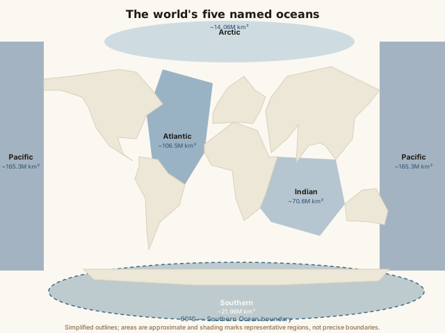
Notice how the Pacific alone spans from the Americas almost all the way to Asia and Australia — visually, it dwarfs the other four combined. The dashed ring around Antarctica is the only ocean boundary on the map that isn't tied to a continent's coastline; every other boundary line roughly follows where one landmass gives way to open water.
Common mistakes
Common Mistakes
Assuming the five oceans are physically separate bodies of water, like five different lakes.
→ They're all one connected World Ocean. The five names describe regions of a single system, not isolated water bodies — this is why a ship or a whale can travel between any two of them without crossing land.
Thinking the Southern Ocean is defined the same way as the other four, by continental coastlines.
→ It's the exception — its boundary is the Antarctic Circumpolar Current (or the 60°S line), not a coastline, since Antarctica only borders it on one side.
Believing ocean size directly predicts ocean depth — assuming the biggest ocean is also uniformly the deepest everywhere.
→ Size (surface area) and depth are different measurements. The Pacific is both the largest and contains the single deepest point on Earth (the Challenger Deep, ~10,935 m), but depth varies enormously within every ocean, including shallow continental shelves within the Pacific itself.
Common misconception
“There are only four oceans — the Southern Ocean isn't a real, separate ocean.”
The Southern Ocean is now formally recognized by major geographic authorities, including National Geographic (since June 2021) and NOAA, as the fifth ocean. It has a genuinely distinct identity: the Antarctic Circumpolar Current keeps its water colder and its ecosystem — including species like Antarctic krill and emperor penguins — measurably different from the subtropical waters just to its north. Some maps and textbooks printed before 2021, or written using older conventions, still show only four oceans, which is where the "only four" belief largely comes from — it reflects an older cartographic standard, not a scientific dispute about whether the water there is genuinely distinct.
A map from the early 2000s labels the ocean around Antarctica as simply the southern edges of the Pacific, Atlantic, and Indian Oceans. Is that map wrong?
Try it yourself
What to do next
What to do next
- Try the calculator above with the Atlantic's area (about 106,000,000 km²) and the Arctic's (about 14,000,000 km²) to compare their share of Earth's surface directly.
- Next time you see a four-ocean map or globe, check its print date — it likely predates the Southern Ocean's 2021 formal recognition.
- Trace a route on a world map from the Pacific to the Atlantic without crossing land, to see for yourself that it's genuinely one connected body of water.
- Read the related entry on Ocean Currents & Their Effects to see how water actually moves between these named regions.