Latitude & Longitude Explained: Reading Earth's Coordinate Grid
Latitude measures angular distance north or south of the equator, and longitude measures angular distance east or west of the Prime Meridian, together pinpointing any location on Earth with a pair of coordinates.
Reading time
— 5 min
Updated
— Aug 16, 2026
Fact-reviewed
— Aug 16, 2026
Key Takeaways
Key Takeaways
1Latitude measures how far north or south of the equator you are; longitude measures how far east or west of the Prime Meridian you are — together they pinpoint any location on Earth.
2Every degree of latitude is roughly the same 111km apart everywhere on Earth, but degrees of longitude shrink toward the poles, from about 111km at the equator down to 0km exactly at the poles.
3The equator is a natural reference point set by Earth's rotation axis; the Prime Meridian is a human decision, fixed at Greenwich, England by international agreement in 1884 — it could have been drawn almost anywhere.
The concept
Latitude and longitude are a pair of numbers that pinpoint any exact location on Earth, the same way a street address pinpoints a building. Latitude tells you how far north or south you are of the equator, the imaginary line circling the globe exactly halfway between the North and South Poles. Longitude tells you how far east or west you are of the Prime Meridian, the imaginary line running through Greenwich, England. Together, a coordinate like "40.7°N, 74.0°W" (New York City) tells you exactly one point on the entire planet.
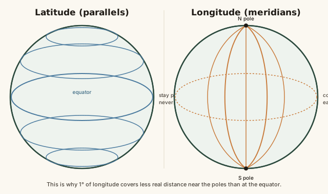
That difference — latitude lines stay evenly spaced, longitude lines converge — isn't just trivia. It has a real, calculable effect on how far apart two coordinates actually sit on the ground.
Quick check
Which stays the same distance apart everywhere on Earth: one degree of latitude, or one degree of longitude?
Worked examples
Example 1: Distance from a change in latitude (baseline case)
Two cities sit at the same longitude but 3 degrees of latitude apart. Since each degree of latitude is roughly 111km anywhere on Earth, the north-south distance between them is approximately 3 × 111 = 333km. This calculation works identically whether the cities are near the equator or near the Arctic Circle, because latitude spacing doesn't change with location — one of the few genuinely simple, universal conversions in geography.
Example 2: Why the same longitude difference means different distances at different latitudes (edge case / variation)
A 10-degree difference in longitude at the equator spans roughly 10 × 111.32 ≈ 1,113km. The exact same 10-degree difference in longitude at 60°N latitude (roughly the latitude of Anchorage or Oslo) spans only about 10 × 111.32 × cos(60°) ≈ 557km — half the equatorial distance, because cos(60°) = 0.5. Near the poles, that same 10-degree longitude gap can shrink to just a few kilometers or less, since all meridians converge to a single point exactly at 90°N and 90°S. This is precisely why longitude requires a cosine correction for the local latitude and latitude doesn't: the physical convergence of the meridian lines is a real geometric effect, not a measurement quirk.
Quick check
Two points share the same 10-degree longitude difference — one pair near the equator, one pair near 60°N. Which pair is physically farther apart?
Example 3: Coordinates in real-world navigation and mapping (real-world / applied case)
Every GPS device, digital map, and international shipping or flight route relies on latitude and longitude as the underlying universal addressing system for the planet — a coordinate pair works identically whether you're using it in a smartphone app, a ship's navigation system, or an emergency rescue coordination center, because it doesn't depend on street names, local languages, or political borders that might not exist or might change. Search-and-rescue teams, for instance, routinely receive locations as raw coordinates from distress beacons, precise enough to guide a helicopter to a specific point in open ocean with no landmarks at all — something no address system built on human infrastructure could ever do.
How it works (visual)
Parallels vs. meridians: why one grid converges and the other doesn't
The visual difference is the entire explanation: parallels stack like evenly spaced rungs on a ladder, while meridians behave like the segments of an orange, wide apart at the equator and pinched together at both ends.
Common mistakes
Common Mistakes
✕
Assuming a degree of longitude is the same real distance as a degree of latitude everywhere.
→ Remember latitude spacing is constant (~111km/degree) everywhere, but longitude spacing shrinks with the cosine of latitude, reaching 0km exactly at the poles.
✕
Mixing up which coordinate is listed first.
→ Standard convention lists latitude first, then longitude (e.g. 40.7°N, 74.0°W) — reversing them silently plots the wrong point, sometimes in a completely different hemisphere.
✕
Treating the Prime Meridian as a natural, scientifically determined line like the equator.
→ Keep in mind the Prime Meridian's location at Greenwich was a human decision made by international vote in 1884 — the equator, by contrast, is fixed by Earth's actual rotation axis.
Common misconception
“Latitude and longitude lines behave the same way and are spaced the same distance apart.”
They're fundamentally different kinds of lines. Latitude lines (parallels) never converge and stay a constant roughly 111km apart everywhere on Earth. Longitude lines (meridians) all converge at exactly two points — the North and South Poles — so the real-world distance covered by one degree of longitude shrinks from about 111km at the equator down to 0km at the poles. Treating them as interchangeable leads to real distance-calculation errors, especially at high latitudes.
Quick check
Why does a degree of longitude shrink to 0km exactly at the North and South Poles?
Try it yourself
Distance from a change in latitude
Approximate distance (km)333
Distance from a change in longitude at a given latitude
Approximate distance (km)556.6
What to do next
What to do next
Try the longitude calculator above at latitude 0 versus latitude 80 with the same degree difference to see the distance shrink dramatically.
Next time you see a coordinate pair, check which number is latitude (always -90 to 90) and which is longitude (always -180 to 180) before reading it.
Look up your own city's latitude and longitude and estimate how far you are from the equator using the latitude calculator above.
Read the related entry on Time Zones Explained to see how longitude directly determines a location's time zone.
FAQ
FAQ
Related terms
Related terms
Latitude
The angular distance of a location north or south of the equator, measured in degrees from 0° at the equator to 90° at the poles.
Longitude
The angular distance of a location east or west of the Prime Meridian, measured in degrees from 0° to 180° in either direction.
Equator
The imaginary line at 0° latitude, equidistant from the North and South Poles, defined by Earth's rotation axis rather than by human convention.
Prime Meridian
The imaginary line at 0° longitude, passing through Greenwich, England, chosen by international agreement in 1884 as an arbitrary reference point.
Parallel
A line of constant latitude, running east-west, always parallel to the equator and to every other parallel.
Meridian
A line of constant longitude, running north-south from pole to pole, converging with every other meridian at both poles.
This entry was researched from public sources and drafted with AI-assisted tools, then edited — errors are still possible. Spot one, or want a topic covered? Read our disclaimer.
 KnowThis