 KnowThis
Key Takeaways
Key Takeaways
- 1Earth rotates 360 degrees every 24 hours, which works out to 15 degrees of longitude per hour — the mathematical basis for every time zone's offset from UTC.
- 2Real time zone borders don't follow that clean 15-degree grid — they bend around national and even sub-national political borders, and a handful of zones use 30- or 45-minute offsets instead of a full hour.
- 3The International Date Line exists because time zone offsets accumulate all the way around the globe back to where they started — crossing it resets the calendar date to keep the 24-hour system consistent with a single global day count.
The concept
The theoretical grid answers "why do time zones exist at all," but the far more common everyday question — "why does this particular border zigzag here instead of running straight" — comes down entirely to which side of a political line you're standing on.
Why does China use a single time zone (UTC+8) for the entire country, even though its longitude span would theoretically justify several?
Worked examples
Example 1: Estimating a UTC offset from longitude (baseline case)
Example 2: A fractional-hour zone (edge case / variation)
India Standard Time is UTC+5:30, a 30-minute offset rather than a whole hour like most zones. What does this reveal about time zone offsets?
Example 3: Crossing the International Date Line on a flight (real-world / applied case)
How it works (visual)
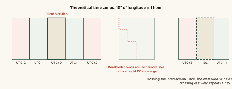
The straight slice edges show the theoretical grid; the dashed jagged line shows how an actual national border reroutes a real time zone boundary around it. The International Date Line sits at the far edge, roughly opposite the prime meridian, doing the job of resetting the calendar so the 24 accumulated hourly offsets don't leave the date perpetually one day ahead of itself.
Common mistakes
Common Mistakes
Assuming every time zone boundary sits exactly on a 15-degree longitude line.
→ Treat the 15-degree grid as the theoretical starting point only — always check the actual zone a specific city or country uses, since political boundaries routinely override the clean math.
Getting the direction backwards when crossing the International Date Line (adding a day when you should subtract, or vice versa).
→ Crossing westward (roughly Asia-to-America direction on a Pacific flight) adds a day; crossing eastward (America-to-Asia) subtracts one — tie it to the direction of longitude increase, not compass intuition alone.
Assuming all time zone offsets are whole hours.
→ Several real zones use 30- or 45-minute offsets (India, Nepal, parts of Australia) — always check the specific offset rather than assuming a round number.
Common misconception
“Time zones are a purely scientific system, drawn as a precise grid based on longitude with no room for local choice.”
The 15-degrees-per-hour relationship is genuine astronomy — it comes directly from Earth's rotation rate. But the actual boundaries countries use are political and administrative decisions layered on top of that math: entire countries adopt a single zone regardless of their longitude span, borders bend around national lines instead of following meridians, and some zones deliberately use fractional-hour offsets. The science sets the scale; politics draws the actual lines.
A traveler crosses the International Date Line heading from Tokyo toward Hawaii (roughly eastward). What happens to the calendar date?
Try it yourself
What to do next
What to do next
- Use the calculator above to estimate a location's theoretical offset, then compare it to the actual zone the country uses — the gap tells you how much political adjustment was made.
- When crossing the International Date Line, remember: eastward (toward the Americas) subtracts a day, westward (toward Asia) adds one.
- Never assume a time zone offset is a whole number of hours — check specifically for India (+5:30), Nepal (+5:45), and similar fractional zones.
- For anything schedule-critical across zones (flights, calls, deadlines), convert every relevant time to UTC first, then back to local time — it removes the offset-direction guesswork entirely.