A watershed is the entire area of land that drains into a given river, meaning a river's size depends less on its length than on how much land — and how much rainfall — feeds into it.
Reading time
— 4 min
Updated
— Sep 24, 2026
Fact-reviewed
— Aug 16, 2026
Key Takeaways
Key Takeaways
1A watershed is all the land that drains into a given river — every drop of rain that falls inside it eventually reaches the same waterway, unless it evaporates or soaks too deep to resurface.
2River 'size' is usually measured by discharge (volume of water flowing per second), not length — the Amazon is shorter than the Nile but carries roughly ten times more water than any other river on Earth.
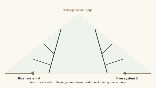
3Watersheds are separated by drainage divides, usually mountain ridges — which side of the ridge a raindrop falls on can determine whether it eventually reaches a completely different ocean.
The concept
A watershed is all the land where rain and snowmelt drain toward the same river system. Picture a funnel: rain that falls anywhere inside the funnel's rim eventually flows to the same spout. A river's watershed can be enormous — the Amazon's covers about 40% of South America — because every stream and tributary feeding into it, however far upstream, is technically part of the same system.
Once you're thinking in terms of watersheds rather than rivers alone, a lot of geography that seemed arbitrary — why certain borders run where they do, why some regions flood and others don't — starts making a lot more sense.
Quick check
Two raindrops fall a few meters apart, exactly on opposite sides of a mountain ridge that forms a drainage divide. What's the most likely outcome?
Worked examples
Example 1: The Amazon watershed (baseline case)
The Amazon basin covers roughly 7 million square kilometers — about 40% of South America — spanning Brazil, Peru, Colombia, and several other countries. Thousands of tributaries feed into it, including the Rio Negro and the Madeira, each with their own smaller sub-watersheds. Because the basin sits in an extremely high-rainfall tropical region, the sheer combination of watershed size and rainfall volume is what gives the Amazon its record-breaking discharge, not its length.
Example 2: The Nile — long river, comparatively modest discharge (edge case)
The Nile is generally considered the longest river in the world at roughly 6,650 km (a few studies argue the Amazon is slightly longer depending on how its source is measured, making this a genuinely contested title). But its watershed passes through arid and semi-arid regions for much of its course, so its average discharge is only around 2,800 cubic meters per second — a small fraction of the Amazon's. It's a clear illustration that "longest" and "biggest" measure two different things entirely.
Example 3: Why watershed boundaries affect real infrastructure decisions (real-world case)
City and regional planners use watershed maps directly when deciding where to build reservoirs, where floodwater is likely to go, and how pollution released upstream will spread. A factory that dumps waste into a stream affects every community downstream in the same watershed, no matter how far away — which is why water-quality regulation is frequently organized by watershed/basin authority rather than by political boundary, since rivers don't respect state or national borders.
How it works (visual)
A watershed: rain, ridges, and where the water goes
Notice both slopes collect many small tributary streams before reaching the main river — a watershed isn't one channel, it's an entire branching network that funnels down to a single outlet.
Common mistakes
Common Mistakes
✕
Assuming the longest river is automatically the 'biggest' river.
→ Compare discharge (water volume per second), not just length — the two rankings often disagree, as with the Nile and the Amazon.
✕
Thinking a watershed is just the river itself.
→ Remember a watershed includes the entire surrounding land area that drains into the river — often thousands of times larger than the river's own surface area.
✕
Assuming pollution or events upstream stay 'local.'
→ Anything entering a river anywhere in its watershed affects everything downstream, which is why watershed-wide thinking matters for water management.
Common misconception
“Rivers always flow south, toward the equator.”
River flow direction depends entirely on the slope of the land, which has nothing to do with which hemisphere or latitude it's in. The Nile, one of the world's most famous rivers, actually flows north — from its sources near the equator in East Africa down to the Mediterranean Sea. Direction is a function of topography, not geography's compass points.
Try it yourself
Convert river discharge to daily water volume
Total water discharged per day (cubic meters)18,057,600,000
What to do next
What to do next
Look up which watershed you live in and which body of water it ultimately drains into — most water authorities publish these maps publicly.
Next time you cross a mountain pass or a notably high ridge on a road trip, consider you may be crossing a drainage divide between two entirely different river systems.
Check where your local river's discharge ranks compared to famous rivers like the Amazon or Nile — it recalibrates what 'big river' really means.
FAQ
FAQ
Related terms
Related terms
Watershed
The entire area of land that drains rainfall and snowmelt into a particular river, lake, or other body of water — also called a drainage basin or catchment.
Tributary
A smaller stream or river that flows into a larger one, rather than directly into the sea.
Drainage divide
The high ground — often a mountain ridge — that separates two neighboring watersheds, determining which side's rain flows into which river system.
Discharge
The volume of water flowing past a point in a river over time, usually measured in cubic meters per second — the standard way to compare how 'big' rivers really are.
This entry was researched from public sources and drafted with AI-assisted tools, then edited — errors are still possible. Spot one, or want a topic covered? Read our disclaimer.
 KnowThis