Global sea level rise comes from two combined physical mechanisms — thermal expansion of warming ocean water and the addition of new water from melting land-based ice sheets and glaciers — and satellite altimetry currently measures the global average rate at a little over 4 millimeters per year, an increase from a slower rate throughout most of the 20th century.
Reading time
— 4 min
Updated
— Aug 22, 2026
Fact-reviewed
— Aug 22, 2026
Key Takeaways
Key Takeaways
1Global sea level rise comes from two combined mechanisms: thermal expansion of warming ocean water, and new water added from melting land-based ice sheets and glaciers — floating sea ice melting doesn't directly add to sea level.
2NOAA satellite altimetry measures global average sea level rise at a little over 4 millimeters per year currently, roughly double the average rate measured through most of the 20th century.
3A rising baseline sea level doesn't need a storm to cause problems — many US coastal cities have documented a sharp rise in 'nuisance flooding' during ordinary high tides as the baseline creeps upward.
The concept
Sea levels rise for two reasons happening at once: warmer ocean water takes up more physical space (the same way most liquids expand when heated), and melting glaciers and ice sheets on land add genuinely new water to the ocean that wasn't there before. NOAA's satellite measurements, tracking the ocean surface continuously since 1993, currently show global average sea level rising by a little over 4 millimeters every year.
Distinguishing thermal expansion from ice melt matters because they respond to warming on different timescales, which is part of why sea level rise is projected to continue for centuries even under scenarios where emissions are reduced soon.
Quick check
If a large amount of floating Arctic sea ice melted completely, how much would that directly raise global sea level?
Worked examples
Example 1: Projecting rise over a decade at the current measured rate (baseline case)
At NOAA's currently measured rate of roughly 4.3 millimeters per year, sea level over a 10-year span would rise by approximately 43 millimeters (about 1.7 inches), assuming the rate stayed constant — which it hasn't; the rate itself has been accelerating over recent decades as ice sheet melt contributes more.
Example 2: Why the rate itself is accelerating, not just the total (edge case / variation)
NASA's satellite record shows the annual rate of sea level rise roughly doubling between the early 1990s (about 2.5 mm/year) and the 2020s (over 4 mm/year) — meaning a simple straight-line projection using an early-1990s rate would meaningfully underestimate future rise. This acceleration is attributed largely to faster-than-previously-expected ice sheet loss from Greenland and Antarctica, which is why climate scientists emphasize the accelerating trend, not just a fixed average rate, when discussing long-term projections.
Example 3: Nuisance flooding becoming routine in coastal US cities (real-world / applied case)
NOAA's tide gauge network has documented a sharp, measurable increase in "high-tide flooding" days — minor coastal flooding during ordinary high tides, requiring no storm at all — in numerous US coastal cities over the past few decades. This is a direct, already-observed consequence of a rising baseline sea level: as the average water level creeps upward, tides that once stayed comfortably below flood stage now regularly exceed it, turning what used to be an occasional nuisance into a routine, multiple-times-per-year occurrence in some locations.
Quick check
Why does a straight-line projection of sea level rise using an early-1990s measured rate tend to underestimate future rise?
How it works (visual)
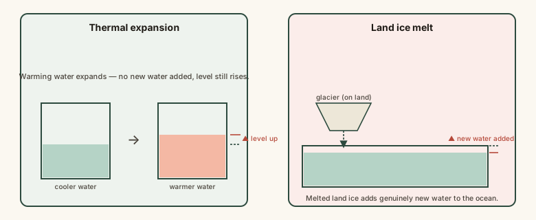
Two combined mechanisms behind rising sea level
Both mechanisms raise sea level simultaneously and add together in the official measurement — thermal expansion doesn't need any new water at all, while land ice melt is entirely about adding water that wasn't previously part of the ocean.
Common mistakes
Common Mistakes
✕
Assuming melting Arctic sea ice is a major direct driver of sea level rise.
→ Floating sea ice melting is close to sea-level-neutral due to displacement — the major ice-related driver is land-based ice sheets and glaciers (Greenland, Antarctica, mountain glaciers) adding genuinely new water.
✕
Projecting future sea level rise using a fixed historical rate rather than the current, faster, accelerating rate.
→ Use the most recent measured rate and account for documented acceleration, since satellite records show the rate roughly doubling over the past three decades.
✕
Assuming sea level rise only matters during major storms.
→ Rising baseline sea level causes measurably more frequent 'nuisance' or high-tide flooding even without any storm, as documented in NOAA's tide gauge records for many US coastal cities.
Common misconception
“Sea level rise is a slow, distant problem that won't have noticeable effects for many decades.”
NOAA's tide gauge data already shows a documented, measurable increase in high-tide ('nuisance') flooding days in numerous coastal US cities over recent decades, without any storm required — a direct, present-day consequence of the rising baseline, not a purely future concern. The longer-term, larger-scale impacts (significant coastal land loss, infrastructure risk) are projected to compound over coming decades, but measurable effects are already occurring now.
Quick check
Is increased coastal flooding purely a future risk from sea level rise, or is it already being observed?
Try it yourself
Project cumulative sea level rise at a given annual rate
Projected cumulative rise (mm)43
What to do next
What to do next
Remember the two-mechanism model: thermal expansion (no new water needed) plus land ice melt (genuinely new water) together produce the measured rise.
When estimating future sea level, use the current, most recently measured rate rather than an older historical average, since the rate has been accelerating.
Check NASA's Sea Level Change Portal (sealevel.nasa.gov) for the real, continuously updated satellite measurement if you want current figures.
If you live in or care about a coastal area, look up whether local tide gauge data shows increased high-tide flooding frequency — it's often a more tangible local signal than the global average figure.
FAQ
FAQ
Related terms
Related terms
Thermal expansion
The physical tendency of water (and most substances) to increase in volume as it warms, which by itself raises sea level even without any added water.
Ice sheet
A massive, continuous body of land-based glacial ice covering more than 50,000 square kilometers — Earth has two, covering Greenland and Antarctica — distinct from floating sea ice, whose melting doesn't directly raise sea level.
Satellite altimetry
A measurement technique using satellites to precisely track the height of the ocean surface from orbit, providing a continuous, global record of sea level change since 1993.
Nuisance flooding
Minor, non-catastrophic coastal flooding during high tides that doesn't require a storm, but has become measurably more frequent in many coastal US cities as the baseline sea level has risen.
This entry was researched from public sources and drafted with AI-assisted tools, then edited — errors are still possible. Spot one, or want a topic covered? Read our disclaimer.
 KnowThis