Natural Disasters: The Real Mechanics Behind Earthquakes, Storms & Floods
Natural disasters — earthquakes, volcanic eruptions, hurricanes, floods, and tsunamis — each have a specific, well-understood physical mechanism that determines where and how they occur.
Reading time
— 8 min
Updated
— Aug 19, 2026
Fact-reviewed
— Aug 19, 2026
Key Takeaways
Key Takeaways
1Earthquake magnitude is logarithmic, not linear — each whole-number increase represents roughly 31.6 times more energy released, so a magnitude 7 earthquake releases about 1,000 times more energy than a magnitude 5, not just '2 more' units of shaking.
2Hurricanes require a specific set of conditions to form — ocean water at least about 26.5°C (80°F), low wind shear, and enough Coriolis effect from Earth's rotation to start the storm spinning — which is exactly why they almost never form within roughly 5° latitude of the equator, despite that being some of the warmest water on Earth.
3Tsunamis are caused by the sudden displacement of a large volume of water — usually an undersea earthquake, landslide, or volcanic eruption — and are physically unrelated to ocean tides, despite the older nickname 'tidal wave.'
4A volcano's eruption style comes down to magma viscosity, not location alone: thin, low-silica magma erupts gently (Hawaii), while thick, high-silica magma traps gas until it explodes (Mount St. Helens) — and it's the fast-moving pyroclastic flow, not the lava, that's usually deadliest.
The concept
Most natural disasters aren't random — each one has a specific physical cause. Earthquakes happen when built-up stress along a crack in Earth's crust (a fault) suddenly releases. Hurricanes form when warm ocean water fuels a spinning storm system. Volcanic eruptions happen when pressurized magma finds a path to the surface. Floods happen when more water arrives in an area than the ground or rivers can absorb or carry away. Knowing the mechanism behind each one is what lets scientists forecast, track, and issue warnings for them well before — or, in an earthquake's case, in the seconds immediately after — they strike.
That's the outline of what causes each hazard. The parts worth understanding in more depth are exactly how much stronger a "bigger" earthquake really is, and why some disasters have geographic restrictions that feel counterintuitive at first. Not every damaging coastal storm is tropical, either — a nor'easter runs on a completely different, cold-core engine than a hurricane does, but can be just as destructive.
Quick check
A magnitude 6 earthquake and a magnitude 8 earthquake are described in the news. How much more energy does the magnitude 8 quake actually release?
Worked examples
Example 1: Comparing energy release between two earthquake magnitudes (baseline case)
Using the relationship energy ratio = 10^(1.5 × magnitude difference), a magnitude 5.0 earthquake compared to a magnitude 7.0 earthquake gives 10^(1.5 × 2) = 10^3 = 1,000 times more energy released by the magnitude 7.0 event. This is why earthquake damage doesn't scale gently with the reported number — the jump from a widely-felt but often low-damage magnitude 5 to a genuinely destructive magnitude 7 represents an enormous real difference in the energy being released underground, even though the two numbers look close together on a printed scale.
Example 2: Why hurricanes rarely form right at the equator (edge case / variation)
The equator has some of the warmest ocean water on Earth — exactly the fuel hurricanes need — yet hurricanes essentially never form within about 5° latitude of it. The missing ingredient is the Coriolis effect, the rotational deflection produced by Earth spinning on its axis. That deflection is strongest at the poles and drops to essentially zero right at the equator, because the effect depends on the local angle between Earth's rotation axis and the surface. Without at least some Coriolis deflection, converging air can't be organized into the rotating, self-sustaining structure that defines a hurricane — thunderstorms can still form over equatorial warm water, but they won't spin up into a cyclone. This is a genuine physical limit, not a coincidence of history, and it's why NOAA's hurricane formation maps show a consistent gap in activity right along the equatorial band even during peak season.
Quick check
The equator has some of the warmest ocean water on the planet, yet hurricanes almost never form there. What's missing?
Example 3: How earthquake early warning systems buy precious seconds (real-world / applied case)
An earthquake releases two main types of seismic waves that travel at different speeds: faster-moving P-waves (roughly 6-8 km/s) arrive first but cause relatively mild shaking, while slower S-waves and surface waves (roughly half the speed of P-waves) arrive later and cause most of the destructive shaking. Earthquake early warning systems, like the USGS's ShakeAlert network along the U.S. West Coast, exploit this speed gap directly: sensors detect the fast, low-damage P-waves near the epicenter and immediately calculate the estimated magnitude and location, then transmit a warning electronically — which travels at the speed of light — to more distant areas before their slower, more damaging S-waves and surface waves arrive. Depending on distance from the epicenter, this can provide anywhere from a few seconds to over a minute of advance warning, enough time to automatically slow trains, open elevator doors, or simply let people take cover.
Example 4: Why some volcanoes ooze lava and others explode (mechanism deep-dive)
Whether an eruption is a slow-moving lava flow or a violent explosion comes down to one property: magma viscosity — how thick and resistant to flow the magma is, which is mostly determined by its silica content. Low-silica (basaltic) magma, like the kind feeding Hawaii's Kilauea, is thin and runny, so dissolved gases can bubble out gradually as it rises, producing relatively gentle, effusive eruptions people can often walk (quickly) away from. High-silica (andesitic or rhyolitic) magma, common at subduction-zone volcanoes like Mount St. Helens or Mount Pinatubo, is thick and sticky — gas gets trapped instead of escaping, building enormous pressure underground until it releases all at once in an explosive eruption. Eruption size is ranked on the Volcanic Explosivity Index (VEI), a logarithmic 0-8 scale structured much like earthquake magnitude: Kilauea's typical eruptions rank around VEI 0-1, the 1980 Mount St. Helens eruption was a VEI 5, and the 1991 Mount Pinatubo eruption, one of the 20th century's largest, was a VEI 6 — each step up representing roughly a tenfold increase in ejected material.
The intuitive picture of lava as the main killer is also backwards for explosive volcanoes: lava usually moves slowly enough to outrun. The deadliest hazard is a pyroclastic flow — a superheated avalanche of gas, ash, and rock fragments that can travel over 100 km/h at temperatures up to 700°C, as documented by the USGS Volcano Hazards Program. Pyroclastic flows, not lava, caused most of the roughly 57 deaths at Mount St. Helens in 1980 and are why volcanologists issue evacuation zones based on flow modeling, not lava-flow speed.
Example 5: Why a flash flood can be more dangerous than a slow-rising river flood (mechanism deep-dive)
Floods aren't one phenomenon — they split into distinct mechanisms with very different warning times. A river (riverine) flood builds over days as sustained rain or snowmelt across an entire watershed pushes a river past its channel capacity; forecasters can often see it coming and issue warnings well in advance. A flash flood, by contrast, develops within about 6 hours of heavy rainfall — often in under 3 — because rain is arriving faster than the ground or storm drains can absorb or carry it away, per NOAA National Weather Service criteria. Urban areas make this worse: pavement and concrete are impervious, so rain that would normally soak into soil instead runs off immediately, concentrating a large rainfall total into a fast, localized surge with almost no lead time. Storm surge, covered above as a hurricane hazard, is a third distinct flood mechanism — wind- and pressure-driven seawater pushed onshore, rather than rainfall runoff at all.
The counterintuitive danger is how little water it takes: according to NOAA, just 15-30 cm (6-12 inches) of fast-moving water can sweep a car off the road, and 30 cm (about 1 foot) can float most vehicles entirely — far less than the wall-of-water image most people picture. This is the basis for NOAA's "Turn Around Don't Drown" guidance: most U.S. flood deaths involve vehicles driven into flooded roads, not people caught in open water, because moving water only a third of a meter deep is already enough to overcome a car's weight and traction.
How it works (visual)
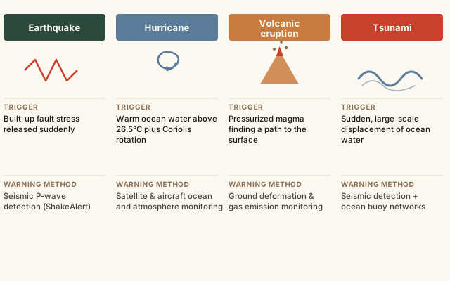
Comparing the trigger conditions behind four major natural disaster types
Each column in the chart starts from a different physical trigger, which is exactly why the warning systems for each hazard look so different: earthquakes are detected using the speed gap between seismic wave types, hurricanes are tracked days in advance using satellites watching ocean temperature and storm structure, volcanic eruptions are anticipated by monitoring ground swelling and gas emissions that build up before magma reaches the surface, and tsunamis are detected using a combination of the triggering earthquake's seismic signal and open-ocean pressure buoys that sense the passing wave.
Common mistakes
Common Mistakes
✕
Treating earthquake 'magnitude' and 'intensity' as the same measurement.
→ Magnitude is a single number describing energy released at the source. Intensity describes how strongly shaking is felt at a specific location, using a scale like the Modified Mercalli scale, and varies with distance from the epicenter and local ground conditions.
✕
Assuming tsunamis are caused by tides, based on the older term 'tidal wave.'
→ Tsunamis are caused by sudden, large-scale water displacement — typically from an undersea earthquake, landslide, or volcanic eruption — and have no physical relationship to the gravitational tidal forces that cause normal ocean tides.
✕
Assuming a location is safe from a given disaster just because it hasn't experienced one in living memory.
→ Recurrence intervals for major earthquakes and floods can span centuries — far longer than personal or even institutional memory — so an area's historical quiet period doesn't necessarily reflect its long-term geological risk.
✕
Assuming lava is the main danger in an explosive volcanic eruption.
→ Lava usually moves slowly enough to outrun. Pyroclastic flows — fast-moving avalanches of superheated gas and ash that can exceed 100 km/h and 700°C — cause most eruption deaths, which is why evacuation zones are based on flow modeling, not lava speed.
✕
Picturing flood danger only as a dramatic wall of rushing water.
→ NOAA data shows just 15-30 cm (6-12 inches) of moving water can sweep a car off the road — most U.S. flood deaths involve vehicles driven into flooded roads, not people caught in open water.
Common misconception
“Earthquakes only happen exactly along the plate boundary lines you'd see drawn on a world map.”
Most major earthquakes do cluster along plate boundaries, but real, well-documented exceptions occur well within plate interiors. The New Madrid Seismic Zone in the central United States, far from any modern plate boundary, produced a sequence of severe earthquakes in 1811-1812 — among the largest in recorded U.S. history — caused by ancient, buried zones of crustal weakness reactivated by regional stress, according to the USGS. These intraplate earthquakes are rarer than boundary earthquakes, but they are real, and building codes in regions like the central and eastern U.S. account for that risk even without a nearby boundary on the map.
Quick check
If earthquakes only happened exactly at visible plate boundaries, how do scientists explain the major 1811-1812 earthquakes in the central United States, far from any boundary?
Try it yourself
Compare energy released between two earthquake magnitudes
Times more energy released by magnitude B vs. A1,000
What to do next
What to do next
Try the calculator above comparing a magnitude you've heard in the news to a smaller one, to see just how much the logarithmic scale changes the real energy difference.
Look up whether your region sits in a recognized earthquake, hurricane, flood, or volcanic hazard zone, even if you haven't personally experienced an event there.
Next time a hurricane is in the news, notice its latitude and connect it to the Coriolis effect requirement for storm formation.
Read the related entry on Earth's Structure & Plate Tectonics to see the full mechanism behind fault formation and plate boundary types.
FAQ
FAQ
Related terms
Related terms
Magnitude
A single number representing the total energy released at an earthquake's source, measured on a logarithmic scale.
Epicenter
The point on Earth's surface directly above where an earthquake originates underground (the focus or hypocenter).
Storm surge
An abnormal rise of ocean water pushed onshore by a storm's winds and low pressure, often the deadliest hazard from a hurricane.
Tsunami
A series of large ocean waves caused by the sudden displacement of a large volume of water, most often from an undersea earthquake, landslide, or volcanic eruption.
Fault
A fracture in Earth's crust along which rock on either side has moved relative to the other, the site where most earthquakes occur.
Coriolis effect
The apparent deflection of moving air and water caused by Earth's rotation, which curves storm systems and is essential to hurricane formation.
Magma viscosity
How thick and resistant to flow a magma is, determined mainly by its silica content — low-silica magma flows easily, high-silica magma is thick and traps gas.
Volcanic Explosivity Index (VEI)
A logarithmic 0-8 scale ranking the size of a volcanic eruption by how much material it ejects, similar in structure to the earthquake magnitude scale.
Pyroclastic flow
A fast-moving, superheated current of volcanic gas, ash, and rock fragments that can travel over 100 km/h at temperatures up to 700°C — the deadliest hazard from an explosive eruption, not the lava itself.
Flash flood
A flood that develops within about 6 hours of heavy rainfall (often much less), caused by rain arriving faster than the ground or drainage system can absorb or carry it away.
This entry was researched from public sources and drafted with AI-assisted tools, then edited — errors are still possible. Spot one, or want a topic covered? Read our disclaimer.
 KnowThis