The European Age of Exploration was a period from roughly the 1420s to the 1520s in which Portuguese and Spanish sailors, driven by the search for direct sea routes to Asian trade goods, mapped ocean routes around Africa and across the Atlantic and Pacific, opening sustained contact between Europe and the Americas.
Reading time
— 5 min
Updated
— Aug 16, 2026
Fact-reviewed
— Aug 16, 2026
Key Takeaways
Key Takeaways
1European exploration was driven mainly by a search for direct sea access to Asian spices and goods, bypassing land routes that passed through Ottoman- and Italian-controlled middlemen.
2Portugal pioneered the African route to Asia (reaching India by sea in 1498), while Spain funded Columbus's 1492 westward voyage that instead reached the Americas — two different routes to the same goal.
3Magellan's expedition (1519–1522) completed the first circumnavigation of the globe, though Magellan himself died partway through and never completed the voyage.
The concept
The Age of Exploration refers to a roughly hundred-year stretch, from the 1420s to the 1520s, when Portuguese and Spanish sailors pushed further into open ocean than Europeans had gone before. Portugal worked its way down the West African coast in stages, looking for a sea route around Africa to Asia's spice markets. Spain took a different bet: sail west across the Atlantic instead, on the assumption the Earth was small enough that Asia lay within reach. That bet, funded for Christopher Columbus in 1492, didn't reach Asia — it reached the Caribbean, an outcome nobody involved had planned for.
Knowing why these voyages happened — competition for a faster, cheaper route to Asian trade goods — makes it easier to place each specific voyage on the same timeline rather than as isolated, disconnected events.
Quick check
What was the main economic motivation behind the Portuguese and Spanish voyages of the Age of Exploration?
Worked examples
Example 1: Vasco da Gama's sea route to India (baseline case)
Portugal's decades-long, incremental mapping of the West African coast — begun under Prince Henry the Navigator in the 1420s — culminated in 1498, when Vasco da Gama's expedition rounded Africa and reached Calicut, India, by sea. This was the payoff of the original goal: a direct maritime route to Asian spice markets that didn't depend on land routes through Ottoman- or Venetian-controlled territory. It established Portugal, briefly, as the dominant European power in the Indian Ocean spice trade.
Example 2: Columbus's 1492 voyage — the same goal, an unplanned outcome (variation / exception)
Christopher Columbus, sailing for the Spanish crown, set out in 1492 with the same underlying goal as da Gama — reaching Asia's trade goods — but via a westward Atlantic crossing instead of the African route. Columbus severely underestimated the Earth's circumference, believing Asia lay a few thousand miles west of Europe. He reached the Caribbean instead, and died in 1506 still believing he had reached the outskirts of Asia. The "exception" here is instructive: this wasn't a voyage aimed at finding a new continent — it was a miscalculated voyage to a known destination that happened to run into an unknown one first.
Example 3: Global shipping lanes today (real-world / applied case)
Many major modern container shipping routes still roughly trace the ocean paths first systematically charted during this period — around the Cape of Good Hope, across the Atlantic, and through the strait Magellan's expedition first navigated at the southern tip of South America (a route later partly superseded by the Panama Canal, opened in 1914). The instruments this era relied on, like the astrolabe, were direct ancestors of the sextant and, eventually, satellite-based GPS navigation used at sea today.
Quick check
Why did Ferdinand Magellan's expedition NOT technically complete the first circumnavigation of the globe under his own command?
How it works (visual)
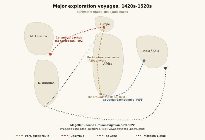
Major exploration voyages, 1420s–1520s
Laid out on a single map, the routes make the era's underlying logic visible: Portugal went south and east around Africa, Spain went west across the Atlantic, and by 1522 the two approaches had effectively met — proving both that the Earth was a single connected globe and that it was far larger than Columbus had assumed.
Common mistakes
Common Mistakes
✕
Treating Columbus's 1492 voyage as the first time any European reached the Americas.
→ Norse sailors reached Newfoundland around 1000 CE, confirmed by archaeology at L'Anse aux Meadows. Columbus's voyage matters because it triggered sustained European contact and colonization, not because it was literally first.
✕
Assuming Portugal and Spain's voyages were separate, unrelated stories.
→ Both were competing attempts at the same goal — direct sea access to Asian trade — pursued in opposite directions around the globe, and they were shaped by the same instruments, ship designs, and economic pressures.
✕
Thinking Magellan personally sailed all the way around the world.
→ Magellan died in the Philippines in 1521; his second-in-command, Juan Sebastián Elcano, completed the voyage with the one surviving ship in 1522.
Common misconception
“Columbus's voyage proved to skeptical Europeans that the Earth was round.”
Educated Europeans already accepted a spherical Earth well before 1492 — ancient Greek astronomers, including Eratosthenes around 240 BCE, had already calculated the Earth's circumference reasonably accurately, and this understanding was standard among medieval scholars, navigators, and mapmakers. The actual disagreement in Columbus's case was about distance, not shape: Columbus badly underestimated how far it was to sail west to reach Asia, and the scholars who doubted his plan were largely correct that the true distance made the voyage impractical — they just hadn't accounted for an unknown continent being in the way.
Quick check
What did informed Europeans in Columbus's era actually believe about the shape of the Earth?
Years since Vasco da Gama's 1498 voyage reached India
Years elapsed528
What to do next
What to do next
Next time Columbus comes up, mentally separate the myth (proving the Earth was round) from the actual historical dispute (the sailing distance to Asia).
When you see a world map, trace the Portuguese route around Africa versus the Spanish route across the Atlantic — they were competing answers to the same trade problem.
Notice how often 'discovery' language obscures that these were often lands already inhabited or, in the Norse case, already briefly visited by other Europeans centuries earlier.
Look up L'Anse aux Meadows next time Viking history comes up — it's a rare case of archaeology directly confirming a pre-Columbian European voyage to North America.
FAQ
FAQ
Related terms
Related terms
Caravel
A small, highly maneuverable Portuguese sailing ship with triangular lateen sails, developed in the 15th century and central to early Atlantic exploration voyages.
Astrolabe
A navigational instrument used to measure the angle of the sun or stars above the horizon, helping sailors estimate their latitude at sea.
Circumnavigation
A voyage that travels all the way around the globe, returning to its starting point.
Columbian Exchange
The widespread transfer of plants, animals, diseases, and people between the Americas, Europe, and Africa that began after 1492, named by historian Alfred W. Crosby.
Treaty of Tordesillas
An agreement signed in 1494 in which Spain and Portugal, with papal involvement, divided newly claimed lands outside Europe along a meridian line.
This entry was researched from public sources and drafted with AI-assisted tools, then edited — errors are still possible. Spot one, or want a topic covered? Read our disclaimer.
 KnowThis