Major Trade Routes: Historical and Modern, and Why Geography Still Decides Them
Trade routes, from the ancient Silk Road to modern container shipping lanes, form where physical geography — coastlines, straits, mountain passes, and wind patterns — makes moving goods most efficient.
Reading time
— 5 min
Updated
— Aug 16, 2026
Fact-reviewed
— Aug 16, 2026
Key Takeaways
Key Takeaways
1The 'Silk Road' wasn't one road — it was a shifting network of overland and sea routes connecting China to the Mediterranean, carrying goods, religions, and diseases alike.
2Ancient sea trade across the Indian Ocean depended on monsoon winds, which reverse direction seasonally — sailors timed entire voyages around a wind pattern that flips twice a year.
3Modern global trade still funnels through the same kind of physical bottlenecks as ancient trade did — narrow straits and canals like Suez, Hormuz, and Malacca carry a disproportionate share of world shipping because geography still hasn't given anyone a shortcut.
The concept
A trade route is a regularly used path for moving goods between regions — by land, by sea, or both. The ancient Silk Road linked China to the Mediterranean through Central Asia, carrying silk, spices, and eventually ideas and religions along with the goods. The trans-Saharan routes moved gold and salt by camel caravan between West and North Africa. Today's equivalent is container shipping — massive ships following ocean lanes that still squeeze through the same handful of narrow passages, like the Suez Canal and the Strait of Malacca, that traders have relied on for centuries.
That reliance on a handful of unavoidable geographic pinch points is the single most useful thing to understand about trade routes, ancient or modern — and it becomes obvious the moment one of those pinch points closes.
Quick check
A large share of world trade still passes through a small number of narrow straits and canals, even with modern ships and navigation technology. Why hasn't technology eliminated this bottleneck?
Worked examples
Example 1: The Silk Road's relay-trade structure (baseline case)
Contrary to the single-road image the name suggests, the Silk Road was a network of overland routes stretching roughly 6,400 kilometers from China through Central Asia to the Mediterranean, active in various forms from around the 2nd century BCE. Few merchants traveled the entire distance themselves — goods typically passed through a relay of trading cities and oasis towns (Kashgar, Samarkand, Bukhara among them), each leg handled by different traders, with goods, prices, and cultural influence accumulating along the way. Silk moved west; goods like wool, silver, and horses moved east — and so did less tangible cargo, including Buddhism's spread into China and, later, the transmission of the Black Death into Europe in the 14th century.
Example 2: The 2021 Suez Canal blockage (edge case / variation)
In March 2021, the container ship Ever Given ran aground and blocked the Suez Canal for six days, halting an estimated hundreds of ships and a significant share of global east-west maritime trade in the process. The incident was a stark, modern demonstration of how much of world trade still depends on a single 193-kilometer, roughly 200-meter-wide passage — with no comparably efficient alternative except sailing an extra 6,000+ kilometers around the Cape of Good Hope. It's the clearest possible edge case showing that a chokepoint isn't just a historical curiosity; a few days of blockage in one narrow channel can ripple through global shipping schedules and prices for weeks afterward.
Quick check
When the Suez Canal was blocked for six days in 2021, why couldn't affected ships simply reroute quickly through a nearby alternative?
Example 3: Suez Canal vs. the Cape route — comparing real transit times (real-world / applied case)
A container ship traveling from Rotterdam to Singapore via the Suez Canal covers roughly 15,000 kilometers. The same trip routed around the Cape of Good Hope, avoiding Suez entirely, covers roughly 24,000 kilometers — about 9,000 kilometers farther. At a typical container ship cruising speed of around 30 km/h (roughly 16 knots), that extra distance alone adds about 300 hours, or roughly 12.5 days, to the voyage — on top of higher fuel costs. This is the exact math shipping companies run every time a chokepoint like Suez faces disruption, and it's why chokepoints carry outsized strategic weight relative to their small size on a map.
How it works (visual)
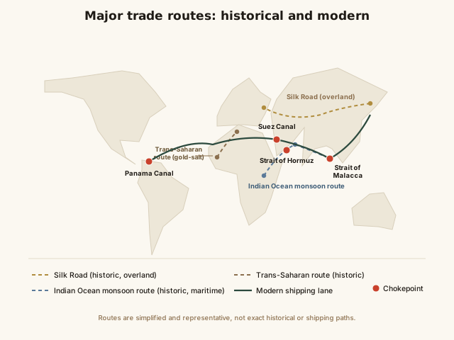
World map: major historical and modern trade routes and chokepoints
Overlay the ancient routes and the modern shipping lanes and the pattern is unmistakable: they cluster around the same physical features — narrow straits, mountain passes, and predictable wind belts — because those features still define the shortest efficient path between regions. Only the vehicles changed; the underlying map of "where it's actually efficient to move things" has stayed remarkably constant for two thousand years.
Common mistakes
Common Mistakes
✕
Picturing the Silk Road as a single, continuous physical road.
→ It was a shifting network of multiple overland and maritime routes used by relay traders — no one road, and no one merchant typically traveled its full length.
✕
Assuming trade routes are mainly a historical topic with little modern relevance.
→ Modern container shipping still runs through the same physical chokepoints — Suez, Hormuz, Malacca — that ancient traders depended on, just with vastly larger cargo volumes.
✕
Thinking a canal or strait's importance is proportional to its size on a map.
→ The Strait of Hormuz and the Suez Canal are geographically tiny compared to the oceans they connect, yet a disruption to either can affect global shipping and energy prices for weeks.
Common misconception
“The Silk Road was a single, fixed road that traders traveled from end to end.”
The Silk Road was actually a shifting network of multiple overland paths and connecting maritime routes, used in relay fashion — goods typically changed hands at successive trading cities rather than a single merchant carrying cargo the entire roughly 6,400-kilometer distance. The very name is a 19th-century invention (coined by geographer Ferdinand von Richthofen in 1877) applied retroactively to describe centuries of decentralized regional trade; the traders themselves never called it that, and the exact routes shifted over time based on political stability, weather, and which oasis cities were currently safest to pass through.
Quick check
What is the most accurate description of the historical Silk Road?
Try it yourself
Shipping transit time: distance ÷ speed
Transit time (hours)500
What to do next
What to do next
Try the calculator above with the Cape of Good Hope route distance (~24,000 km) instead of the Suez route (~15,000 km) to see exactly how many extra hours a closed chokepoint adds.
Next time you read about a shipping delay or price spike in the news, check whether a chokepoint like Suez, Hormuz, or Malacca is involved — it usually is.
Look at a world map and trace the shortest sea path between two major ports — notice how often it funnels through a strait or canal rather than open ocean.
Read the related entry on Energy Resources Around the World to see why chokepoints matter especially for oil and gas shipments.
FAQ
FAQ
Related terms
Related terms
Trade route
A regularly used path — overland, maritime, or both — along which goods, people, and ideas move between regions.
Chokepoint
A narrow passage, such as a strait or canal, through which a large share of trade or shipping must pass because no practical alternative route exists.
Monsoon
A seasonal wind pattern that reverses direction roughly twice a year, historically used by sailors in the Indian Ocean to time voyages in one direction and returns in the other.
Containerization
The mid-20th-century shift to shipping goods in standardized steel containers, which sharply cut loading time and cost and reshaped global trade logistics.
Entrepôt
A trading port or city that exists mainly to receive, store, and re-export goods rather than to produce them itself.
This entry was researched from public sources and drafted with AI-assisted tools, then edited — errors are still possible. Spot one, or want a topic covered? Read our disclaimer.
 KnowThis