 KnowThis
Key Takeaways
Key Takeaways
- 1GPS works by timing radio signals from orbiting satellites, not by using your phone's cellular data or WiFi — a phone with no signal at all can still get a GPS location if it can see the sky.
- 2One satellite alone only narrows your location to a sphere; it takes distances from at least four satellites, calculated through trilateration, to pin down a single point in three dimensions and correct for clock error.
- 3GPS receivers only listen for satellite signals — they never transmit anything back to the satellites, which is why a phone tracking your location doesn't need to 'send a signal to space' to do it.
The concept
The most common misunderstanding about GPS is exactly which network it depends on — and testing the airplane-mode scenario directly makes the actual mechanism obvious.
A phone has cellular data and WiFi both turned off, but its location services are on and it has a clear view of the sky. Can it still determine its GPS location?
Worked examples
Example 1: Getting a location fix outdoors with a clear sky (baseline case)
Why does a GPS receiver typically need signals from at least four satellites, not just three, to get an accurate fix?
Example 2: Weak GPS signal inside a car or near tall buildings (edge case / variation)
Why does GPS accuracy often get noticeably worse in a dense downtown area with tall buildings?
Example 3: Why map apps show a location almost instantly, not after a long wait (real-world / applied case)
Calculating a GPS fix from a cold start — a phone that's been off or in airplane mode for a while — can take tens of seconds, because the receiver first has to download orbital data broadcast slowly by each satellite before it can even begin timing signals accurately. Everyday map apps avoid this delay using assisted GPS: the phone briefly uses its cellular or WiFi connection to download the same orbital data from the network almost instantly instead of waiting on the slow satellite broadcast, cutting the time to first fix from tens of seconds down to a second or two. The satellite signals still do the actual position calculation — the network connection just speeds up the setup step beforehand.
How it works (visual)
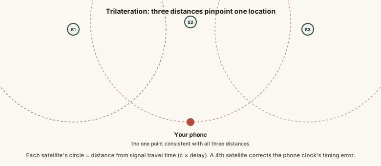
Each circle represents every possible point that particular distance from that particular satellite — only one location on the ground satisfies all of them simultaneously, which is exactly the point trilateration solves for.
Common mistakes
Common Mistakes
Assuming GPS requires cellular data or WiFi to function.
→ GPS calculates location directly from satellite signals; cellular and WiFi only speed up the very first fix through assisted GPS, and aren't required for the position math itself.
Believing your phone 'sends a signal' to satellites so they can find it.
→ GPS receivers are listen-only — they never transmit to satellites. The satellite broadcasts and the receiver's own clock, not any signal sent from the phone, are what determine location.
Expecting the same GPS accuracy indoors, in tunnels, or in dense downtown areas as in open outdoor spaces.
→ Buildings and other obstructions block or reflect satellite signals, degrading accuracy or preventing a fix entirely — this is a signal-availability limit, not a flaw in the calculation.
Thinking a slow first GPS fix means something is broken.
→ A cold-start fix can take tens of seconds while the receiver downloads orbital data directly from satellites; this is normal and is exactly what assisted GPS is designed to speed up.
Common misconception
“GPS uses your phone's internet connection to find your location.”
GPS calculates location entirely from timed radio signals broadcast by orbiting satellites — a phone with no cellular signal and WiFi turned off can still get an accurate GPS fix outdoors. Internet or cellular data can make the very first fix faster, through a technique called assisted GPS that downloads satellite orbital data over the network instead of waiting for the satellites to broadcast it, but the core position calculation itself runs on satellite signals alone.
Try it yourself
A simplified illustration of the core GPS math: distance equals the speed of light multiplied by how long the signal took to travel. Real GPS satellites orbit at roughly 20,200 km altitude, giving one-way signal delays typically in the tens of milliseconds.
This shows only the basic distance-from-time-delay relationship for one satellite. Actual GPS positioning combines this calculation across at least four satellites at once and corrects for receiver clock error, atmospheric delay, and other small effects.
What to do next
What to do next
- If your phone's GPS seems slow to find you, give it a clear view of open sky for the fastest first fix.
- Remember that airplane mode disabling cellular and WiFi doesn't disable GPS reception itself — GPS is receive-only and doesn't need those radios.
- Expect reduced GPS accuracy indoors, in tunnels, and around tall buildings — this is a signal-availability limit, not a bug.
- Read the related entry on how airplane mode actually works to see exactly which radios it does and doesn't turn off.