 KnowThis
Key Takeaways
Key Takeaways
- 1El Niño and La Niña are opposite phases of one ocean cycle (ENSO) — a shift in Pacific surface temperature, not a storm or a single weather event.
- 2The trigger is trade winds: when they weaken, warm water that's normally piled up near Asia sloshes back east toward South America, and the atmosphere's rain patterns follow the heat.
- 3An event is declared only once the Pacific stays 0.5°C or more above (El Niño) or below (La Niña) average for several months running — a one-week warm spell doesn't count.
The concept
That's the mechanism. What it actually does to weather on the other side of the planet depends on where you are relative to that shifted heat — which is where the effects stop being abstract.
Trade winds over the tropical Pacific suddenly weaken for several months. What is the most direct consequence?
Worked examples
Example 1: The normal (neutral) Pacific state
Example 2: A strong El Niño (1997-98)
Example 3: How forecasters use it in practice
Why did the 1997-98 El Niño cause flooding in Peru and drought in Indonesia at the same time?
How it works (visual)
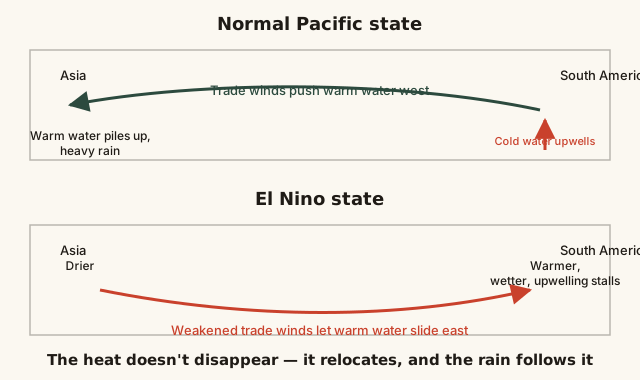
Notice that nothing in the diagram adds or removes heat from the planet overall — the warm water and the rain it produces simply relocate from one side of the Pacific to the other, which is why El Niño's effects show up as opposite anomalies (wet vs. dry) in different regions simultaneously.
Common mistakes
Common Mistakes
Calling El Niño itself "a storm" or a single weather event.
→ El Niño is a sustained ocean-temperature pattern lasting months; it changes the odds and location of storms and rainfall, but isn't a storm on its own.
Assuming El Niño means "wetter everywhere" and La Niña means "drier everywhere."
→ Each phase brings wetter conditions to some regions and drier conditions to others, depending on where the shifted rain belt lands — check region-specific outlooks, not a single global rule.
Treating El Niño and climate change as the same phenomenon.
→ ENSO is a natural, recurring cycle that has operated for centuries; climate change is a separate long-term warming trend that can influence how intense individual El Niño/La Niña events become, but doesn't cause the cycle itself.
Common misconception
“El Niño is a specific storm or hurricane that forms in the Pacific.”
El Niño is a temperature pattern, not a storm. It describes a stretch of the equatorial Pacific Ocean running warmer than average for several consecutive months, driven by weakened trade winds. That warmth reorganizes where the atmosphere's rain-producing rising air sits, which in turn shifts storm tracks and rainfall across the Americas, Asia, and Australia — but the phenomenon itself is oceanic and atmospheric-scale, not a single identifiable storm system.
What to do next
What to do next
- Check NOAA's Climate Prediction Center ENSO outlook before making seasonal plans that depend on rainfall (agriculture, water storage, travel timing) in an ENSO-sensitive region.
- Remember that ENSO shifts probabilities, not certainties — treat a seasonal outlook as a tilted set of odds, not a guaranteed forecast.
- If you live somewhere ENSO-sensitive (the U.S. West Coast, Peru, Indonesia, eastern Australia, India's monsoon belt), look up which phase historically means wetter vs. drier for your specific region rather than assuming a global default.