 KnowThis
Key Takeaways
Key Takeaways
- 1Australia is Earth's smallest continent at about 7.69 million km² — and the only continent that is also a single country, with no internal international borders.
- 2Roughly two-thirds of Australia is arid or semi-arid Outback, but the continent also has tropical rainforest in the northeast, temperate forest in the southeast, and snowfields in its alpine regions — it is not a desert everywhere.
- 3Oceania is a much broader region than Australia alone, made up of thousands of Pacific islands grouped into Melanesia, Micronesia, and Polynesia, most of which sit on entirely different, non-continental crust.
The concept
The gap between "Australia" and "Oceania" trips a lot of people up, and it's worth pinning down with the actual scale involved before moving to the climate question that trips up even more people.
Are 'Australia' and 'Oceania' the same thing?
Worked examples
Example 1: Australia's share of Earth's land area (baseline case)
Example 2: Australia's mainland high point vs. Oceania's true high point (edge case / variation)
Why do some 'Seven Summits' lists cite Puncak Jaya (4,884 m, New Guinea) instead of Mount Kosciuszko (2,228 m, mainland Australia) as the continent's highest peak?
Example 3: Why most Australians live on a thin coastal strip (real-world / applied case)
With roughly two-thirds of the continent classified as arid or semi-arid, fresh water access has directly shaped where Australia's population settled. The vast majority of Australians live within a relatively narrow band along the eastern and southeastern coast — cities like Sydney, Melbourne, and Brisbane — where rainfall is reliable enough to support large populations, agriculture, and reservoirs. The Outback interior, by contrast, holds only a small fraction of the national population despite covering most of the continent's land area, a pattern driven almost entirely by water availability rather than by any other single factor. This is a clear, observable case of climate geography directly dictating settlement patterns at a national scale — the map of "where people live in Australia" and the map of "where reliable rainfall exists in Australia" line up closely.
How it works (visual)
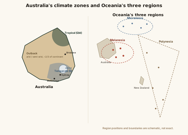
Notice how the population-dense zones on the map cluster almost exactly where the climate zones shift away from arid Outback — along the wetter eastern and southeastern coastal fringe. Zoom out to the Pacific-wide view and Australia becomes just one (admittedly the largest) landmass inside the much bigger patchwork of Oceania's three island regions.
Common mistakes
Common Mistakes
Assuming Australia is desert or near-desert everywhere.
→ About two-thirds of Australia is arid or semi-arid, but the continent also has tropical rainforest, temperate forest, and alpine snowfields — its climate is genuinely varied, not uniform.
Using 'Australia' and 'Oceania' interchangeably.
→ Australia is one continent; Oceania is a much larger regional grouping that includes Australia plus thousands of separate Pacific islands across Melanesia, Micronesia, and Polynesia.
Assuming New Zealand and small Pacific islands sit on the same type of crust as Australia.
→ Australia and New Zealand sit on continental-type crust, while most smaller Pacific islands are oceanic islands — independently formed volcanic peaks or coral atolls with no continental connection.
Common misconception
“Australia is a desert continent, mostly uninhabitable outside a few coastal cities.”
Roughly two-thirds of Australia's interior is classified as arid or semi-arid, which is where the "desert continent" reputation comes from — but Australia also has tropical rainforest in the far north, temperate forest across the southeast, fertile agricultural land, and even alpine regions in the Australian Alps that receive enough snow to support a ski season. The reason most Australians live along the coast isn't that the interior is "uninhabitable" in an absolute sense — it's that population settled where water is most reliably available, the same pattern that shapes population distribution on every continent.
Is it accurate to describe Australia as a desert everywhere outside a handful of coastal cities?
Try it yourself
What to do next
What to do next
- Compare a population-density map of Australia against a rainfall map — notice how closely the populated coastal fringe lines up with reliable rainfall.
- Look up whether a given 'Seven Summits' list uses Mount Kosciuszko or Puncak Jaya, and check which continental definition (Australia vs. Oceania) it's using.
- Find Melanesia, Micronesia, and Polynesia on a Pacific map and notice how much larger Oceania is than Australia alone.
- Read the related entry on Mountains & Mountain Ranges to see how Puncak Jaya's volcanic-and-collision origin compares to mountain formation on the other continents.