 KnowThis
Key Takeaways
Key Takeaways
- 1South America is Earth's fourth-largest continent at about 17.84 million km², defined by the Andes running the length of its western edge and the Amazon Basin covering roughly 40% of its interior.
- 2The Amazon River carries more water than the next several largest rivers on Earth combined — by discharge volume it's not a close contest, even though its exact length versus the Nile remains genuinely debated.
- 3South America holds both climate extremes: the Atacama Desert, the driest non-polar place on Earth, sits less than 2,000 km from the Amazon rainforest, one of the wettest.
The concept
That dry-to-wet extreme within a single continent is a good entry point into South America's other defining contrast: how "world's longest river" is measured, and why the Amazon and the Nile keep trading that title depending on the method used.
The Atacama Desert (Chile) and the Amazon Rainforest are both in South America, separated by less than 2,000 km, yet one is the driest non-polar place on Earth and the other among the wettest. What best explains this?
Worked examples
Example 1: South America's share of Earth's land area (baseline case)
Example 2: Amazon vs. Nile — the "longest river" debate (edge case / variation)
Is the Amazon or the Nile the 'world's longest river'?
Example 3: The Andes' role in South America's climate and agriculture (real-world / applied case)
The Andes don't just define South America's skyline — they actively shape rainfall patterns across the entire continent. Moist air moving west off the Atlantic is forced upward as it crosses the Amazon Basin and then slams into the eastern slopes of the Andes, dropping most of its remaining moisture before crossing the peaks — which is the direct cause of the extreme dryness on the range's western, Pacific-facing side, including the Atacama. This same rain-shadow mechanism supports high-altitude agriculture: the Altiplano, a high plateau shared by Bolivia and Peru at around 3,750 meters, developed distinct farming practices (terracing, potato cultivation adapted to thin air and cold nights) precisely because of the unique climate the surrounding peaks create — a direct, observable link between mountain geography and how millions of people farm today.
How it works (visual)
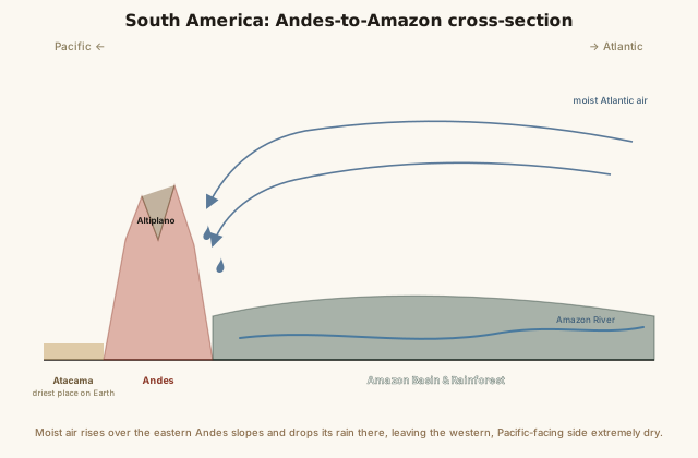
Follow the moisture arrows from the Atlantic and the whole pattern clicks into place: warm, wet air crosses the Amazon Basin, climbs the Andes' eastern face, and drops nearly all its remaining rain before it can cross to the Pacific side — which is exactly why the Atacama, sitting in the Andes' rain shadow, stays so extraordinarily dry.
Common mistakes
Common Mistakes
Assuming the Amazon rainforest covers all of South America.
→ The Amazon Basin covers roughly 40% of South America, concentrated in the north — the continent also contains deserts (Atacama), grassland plains (Pampas), and high plateaus (Altiplano).
Treating 'longest river' and 'largest river' as the same measurement.
→ Length (Nile vs. Amazon) is genuinely contested; discharge volume is not — the Amazon carries far more water than any other river on Earth, including the Nile, by a wide margin.
Assuming a desert must be hot, so a 'driest place on Earth' claim about a coastal region seems implausible.
→ Dryness is defined by lack of precipitation, not temperature — the Atacama's extreme dryness comes from the Andes rain shadow and a cold offshore current, not desert heat.
Common misconception
“The Amazon River is unambiguously the world's longest river, full stop.”
The Amazon is unambiguously the world's largest river by discharge — it carries more water than the next seven largest rivers on Earth combined. But "longest" is a genuinely different and more contested measurement: for over a century, the Nile has been the more commonly cited longest river, and while some expeditions have proposed Amazon source measurements that would edge it ahead, the exact length of both rivers depends on which tributary is counted as the true headwater. Conflating "largest" and "longest" produces a confident-sounding claim that oversimplifies a genuinely unsettled geographic question.
Which claim about the Amazon River is accurate?
Try it yourself
What to do next
What to do next
- Trace the Andes on a map from Venezuela down to the southern tip of Chile and Argentina and notice how consistently it hugs the Pacific coast for the entire 7,000 km.
- Compare South America's population density (using the calculator above) against Asia's or Europe's from their own entries to see how much emptier South America's interior is by comparison.
- Look up current Amazon-vs-Nile length claims from two different sources and see whether they agree — it's a genuinely live debate, not settled trivia.
- Read the related entry on Rivers & Major Watersheds to see how the Amazon's discharge compares to other major world rivers in detail.