 KnowThis
Key Takeaways
Key Takeaways
- 1Africa is Earth's second-largest continent at about 30.37 million km² — large enough to hold the United States, China, India, and most of Europe combined, even though standard world maps make it look barely bigger than Greenland.
- 2The equator runs almost exactly through Africa's middle, giving it a rare, roughly symmetric band of climates — desert, semi-arid, savanna, and rainforest repeat in mirrored order north and south of the equatorial belt.
- 3The Great Rift Valley, a roughly 6,000 km tectonic fracture, is slowly splitting East Africa away from the rest of the continent — millions of years from now it's expected to become a new ocean basin.
The concept
That size distortion isn't a matter of opinion — it comes from a specific, measurable property of the map projection most people grew up looking at, and it's worth working through with real numbers.
On a standard Mercator world map, Greenland (2.17 million km²) looks close in size to Africa (30.37 million km², roughly 14 times larger). Why?
Worked examples
Example 1: Africa's share of Earth's land area (baseline case)
Example 2: Why Kilimanjaro is a "freestanding" mountain (edge case / variation)
What makes Mount Kilimanjaro geologically unusual compared to most other continents' highest peaks?
Example 3: The Sahel as a climate transition zone under pressure (real-world / applied case)
The Sahel — a roughly 5,900 km-wide semi-arid band running across Africa just south of the Sahara, through countries like Mali, Niger, Chad, and Sudan — sits precisely at the boundary between desert and savanna, which makes it one of the most climate-sensitive regions on the planet. Because average rainfall there is already marginal for agriculture, relatively small shifts in seasonal rain patterns can push farmland toward desertification or back toward productive grassland. Governments and international agencies have backed large-scale efforts like the "Great Green Wall," an initiative to plant a band of vegetation across the Sahel to slow desert expansion and stabilize soil — a direct, applied response to the fact that this narrow climate band, more than almost any other region on Earth, sits on a razor's edge between two very different landscapes.
How it works (visual)
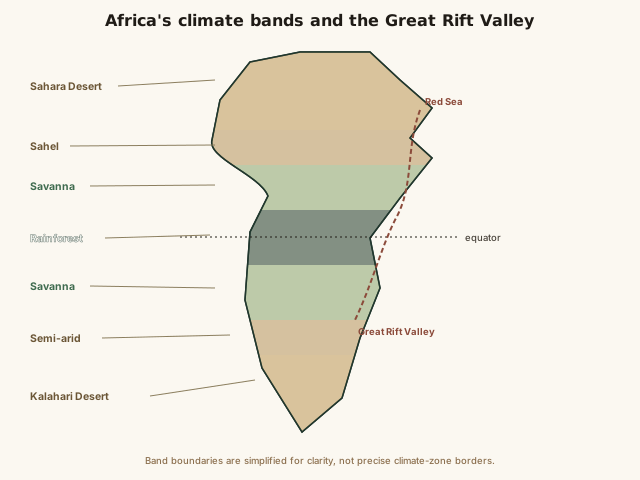
Read the map from the equator outward in either direction and the bands repeat in the same order — rainforest, savanna, semi-arid, desert — a near-mirror pattern that exists because the same global air-circulation belts sit above and below the equator symmetrically. The rift line cutting through East Africa marks where that otherwise continuous landmass is actively being pulled apart, millimeters at a time.
Common mistakes
Common Mistakes
Judging Africa's size from a standard Mercator world map.
→ Mercator maps inflate high-latitude regions and shrink equatorial ones — Africa's real land area (30.37 million km²) is large enough to fit the US, China, India, and most of Europe combined.
Treating 'Africa' as a single climate or ecosystem.
→ Africa spans desert, semi-arid steppe, savanna, and rainforest in mirrored bands north and south of the equator — it has some of the greatest climate diversity of any continent.
Assuming Africa's highest mountain, Kilimanjaro, is part of a larger range like the Himalayas or Andes.
→ Kilimanjaro is a freestanding volcanic peak, geologically isolated from any mountain chain, which is what makes it the world's tallest freestanding mountain.
Common misconception
“Africa is a single country, or at least a single uniform climate and culture, rather than a continent of enormous internal diversity.”
Africa is home to 54 recognized sovereign countries, more than 2,000 spoken languages, and every major climate type from hyper-arid desert to dense equatorial rainforest to snow-capped mountain peaks (Kilimanjaro has permanent glaciers near the equator). Its land area is large enough to contain the US, China, India, Japan, and most of Europe combined. Treating Africa as one uniform place — climatically, culturally, or politically — erases genuinely enormous variation across its 54 countries and multiple distinct climate bands.
Why is it inaccurate to describe Africa's climate or culture as broadly uniform across the continent?
Try it yourself
What to do next
What to do next
- Try the calculator above at latitude 0 (the equator, where Africa sits) versus latitude 60 (near Scandinavia or southern Alaska) to see how much the Mercator projection stretches high-latitude land.
- Look up the 'True Size of Africa' comparison graphic and check how many familiar countries fit inside Africa's real outline.
- Trace the Great Rift Valley on a map from the Red Sea down through Ethiopia, Kenya, and Tanzania, and note the chain of lakes that mark it.
- Read the related entry on Climate Zones Explained to see how the same equatorial circulation pattern that shapes Africa's climate bands shows up worldwide.