 KnowThis
Key Takeaways
Key Takeaways
- 1Europe and Asia are not separated by an ocean — they sit on one unbroken landmass called Eurasia, divided only by a conventional line running along the Ural Mountains, the Ural River, the Caspian Sea, and the Caucasus.
- 2Europe is the second-smallest continent by land area (about 10.18 million km²) but one of the most densely populated and most peninsula-heavy, giving it an unusually long coastline relative to its size.
- 3Europe's highest peak depends entirely on where you draw the Europe-Asia line: Mount Elbrus (5,642 m, Russia) if the Caucasus counts as European, or Mont Blanc (4,808 m, France/Italy) under a stricter definition.
The concept
That glacially carved, peninsula-heavy shape isn't just a curiosity — it's the direct reason Europe developed so many distinct coastal nations in such a small area, which is worth working through with real measurements.
Why does Europe have so many more countries packed into its land area than, say, Africa, despite Africa being roughly three times larger?
Worked examples
Example 1: Europe's share of Earth's land area (baseline case)
Example 2: Where is Europe's highest point, really? (edge case / variation)
Sources disagree on whether Europe's highest peak is Mount Elbrus (5,642 m) or Mont Blanc (4,808 m). Why does this disagreement exist?
Example 3: The North European Plain and where Europe's population actually lives (real-world / applied case)
The North European Plain — flat, glacially smoothed lowland stretching from southern France through the Netherlands, Germany, Poland, and into Russia — is one of the most agriculturally productive and densely populated stretches of land on Earth, and it's directly why Europe's population clusters so heavily in its western and central belt rather than spreading evenly across the continent. Contrast that with Scandinavia and the Alps, where thin soils and steep terrain support far lower population densities. This unevenness is a direct, observable consequence of the last ice age: glaciers flattened and enriched the plain with fertile sediment while scraping the mountainous north down to bare rock, and those Ice Age effects are still shaping where tens of millions of Europeans live today.
How it works (visual)
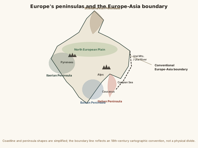
Notice how much of Europe's outline is made of peninsulas rather than one solid coastline — that shape is the physical reason so much of European history involves distinct maritime and land powers developing side by side in a relatively small area. Compare that jagged western edge to the single straight dashed line marking the Ural boundary in the east: one side of Europe's border is defined by real coastline, the other by a line geographers agreed on.
Common mistakes
Common Mistakes
Assuming Europe and Asia are separated by an ocean or sea, like most continent pairs.
→ They're one continuous landmass (Eurasia). The dividing line runs along the Ural Mountains, Ural River, Caspian Sea, and Caucasus — a convention, not a coastline.
Treating Russia as a purely European country.
→ Russia is transcontinental — about 77% of its territory lies in Asia, east of the Urals — even though most Russians live in the smaller European portion.
Assuming Europe's small land area means it has a small population.
→ Europe holds around 745 million people on just 6.8% of Earth's land — among the highest population-to-area ratios of any continent.
Common misconception
“Europe and Asia are separate continents because they're divided by an ocean, the same way Africa is separated from South America by the Atlantic.”
Europe and Asia share one unbroken landmass — there is no ocean, sea, or physical gap between them anywhere along their boundary. The line separating them runs entirely over land: the Ural Mountains, the Ural River, the Caspian Sea, and the Caucasus range. This makes Europe and Asia unique among the standard seven-continent model — every other continent pair is separated by open water or a narrow strait, while "Eurasia" is treated as two continents purely by historical and cultural convention, not physical geography.
What actually separates the continents of Europe and Asia from each other?
Try it yourself
What to do next
What to do next
- Trace the Ural Mountains on a map from the Arctic Ocean south to the Caspian Sea and notice that no coastline runs alongside most of that line.
- Compare Europe's share of Earth's land area (about 6.8%) against Asia's (about 29.9%) using the calculator above, and connect the gap to how densely populated Europe still is.
- Look up whether Mount Elbrus or Mont Blanc is listed as 'Europe's highest peak' in three different reference sources, and notice which Europe-Asia convention each one uses.
- Read the related entry on Geography of Asia to see the same Ural Mountains boundary from the other side.