 KnowThis
Key Takeaways
Key Takeaways
- 1Asia is Earth's largest continent by a wide margin — roughly 44.58 million km², about 30% of the world's land area, and home to nearly three in five people alive today.
- 2Asia's terrain runs to extremes: it holds Earth's highest point (Mount Everest, 8,849 m) and one of its lowest exposed land points (the Dead Sea shore, about 430 m below sea level), often within a few thousand kilometers of each other.
- 3Asia and Europe sit on one continuous landmass called Eurasia — the line between them, running along the Ural Mountains, is a historical and cultural convention, not a physical break like an ocean.
The concept
Knowing where Asia's boundary is drawn is one thing; knowing what actually sits inside that boundary — in terms of scale, elevation, and climate — is where the continent's real character shows up.
Which statement correctly describes the boundary between Europe and Asia?
Worked examples
Example 1: Asia's share of Earth's land area (baseline case)
Example 2: Mount Everest and the Dead Sea — Asia's elevation extremes (edge case / variation)
Mount Everest and the Dead Sea shore are both in Asia, at opposite elevation extremes. What causes this contrast?
Example 3: The monsoon and Asian agriculture (real-world / applied case)
Each summer, the Asian landmass heats up faster than the surrounding Indian Ocean, creating a large area of low pressure over land that pulls in moist ocean air. As that air rises over the Western Ghats and the Himalayan foothills, it cools and dumps enormous amounts of rain — the town of Mawsynram in northeast India averages over 11,000 mm of rainfall a year, among the highest anywhere on Earth, almost entirely concentrated in the June-to-September monsoon window. This single seasonal weather pattern effectively sets the planting calendar for rice, wheat, and other staple crops across a region that includes well over a billion farmers and consumers, which is why a delayed or weak monsoon can move national food-price statistics in India and Bangladesh within a single season.
How it works (visual)
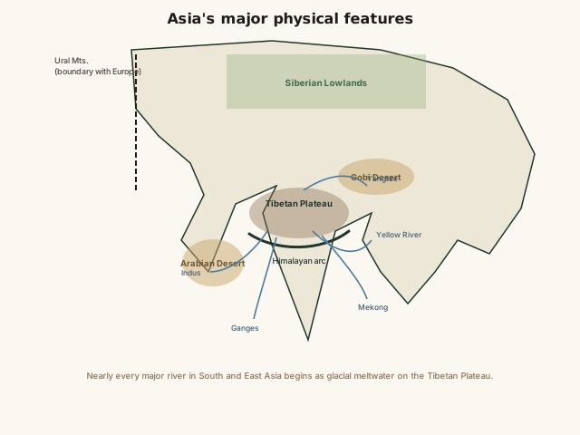
Trace the rivers on the map back to their source and nearly all of them converge on the same high-elevation core: the Tibetan Plateau and its surrounding ranges. That single geographic fact — one plateau feeding water to more than a dozen countries downstream — is why the region is sometimes called Asia's "water tower," and why changes to its glaciers are watched closely by hydrologists well beyond Asia's borders.
Common mistakes
Common Mistakes
Assuming Asia's climate is mostly hot and tropical.
→ Asia holds both the coldest inhabited place on Earth (Oymyakon, Siberia, which has recorded below -60°C) and hot tropical regions near the equator — it's the most climatically diverse continent, not a uniformly warm one.
Treating 'the Middle East' and 'Asia' as separate, unrelated regions.
→ The Middle East (Saudi Arabia, Iran, Turkey, etc.) is conventionally part of West Asia — it's a cultural/political subregion label, not a separate continent.
Assuming the largest country by land area headquartered mostly in Asia is also Asia's most populous.
→ Russia is the largest country by area with most of its territory in Asia, but the large majority of Russians live west of the Urals in the European fifth — China and India, not Russia, are Asia's most populous countries.
Common misconception
“Asia's incredible size and population mean it functions as one broadly similar cultural and geographic region.”
Asia is the most internally diverse continent on Earth by nearly every measure. It spans dozens of major language families, every major world religion originated or has deep historical roots there, and its terrain ranges from permafrost in Siberia to equatorial rainforest in Indonesia. Grouping "Asia" as a single cultural or geographic unit obscures more than it explains — a better mental model treats it as several distinct regions (East, South, Southeast, Central, and West Asia) that happen to share one landmass.
Why is it misleading to describe Asia as one broadly uniform region?
Try it yourself
What to do next
What to do next
- Trace the Ganges, Yangtze, or Mekong back to its source on a map and notice how many of Asia's major rivers begin on the same Tibetan Plateau.
- Next time you see a monsoon-related news story from India or Bangladesh, connect it to the seasonal land-ocean heating pattern that drives it, not just 'heavy rain.'
- Compare Asia's 29.9% share of Earth's land area against Africa's roughly 20.4% using the calculator above, swapping in each continent's area.
- Read the related entry on Continents & Oceans Overview to see how Asia's boundary conventions compare with the other six continents.