 KnowThis
Key Takeaways
Key Takeaways
- 1North America is Earth's third-largest continent at about 24.71 million km², built from distinct west-to-east bands: the young, rugged Rocky Mountains, the flat Great Plains, and the old, worn-down Appalachian Mountains.
- 2The continent's highest point is Denali, Alaska, officially remeasured by the USGS in 2015 at 20,310 feet (6,190 meters) using modern GPS survey methods — 10 feet lower than the figure used for the previous six decades.
- 3North America's conventional southern boundary is the Isthmus of Panama, a land bridge narrowing to about 80 km — everything south of it, including all of Central America south of that point, is conventionally part of North America too, not a separate landmass.
The concept
Those west-to-east bands aren't just a visual pattern — they reflect real differences in the age and formation history of each region, which becomes clearer with specific numbers.
The Rocky Mountains are jagged and sharply peaked, while the Appalachian Mountains are rounded and much lower. What best explains this difference?
Worked examples
Example 1: North America's share of Earth's land area (baseline case)
Example 2: Why Denali's official height changed in 2015 (edge case / variation)
In 2015, the USGS revised Denali's official elevation from 20,320 feet down to 20,310 feet. What does this change reflect?
Example 3: The Continental Divide and where North America's rivers actually go (real-world / applied case)
The Continental Divide runs along the crest of the Rocky Mountains from Alaska down through Canada, the United States, and into Mexico, and it determines the ultimate destination of nearly every drop of rain that falls on the continent's western half. Rain falling just east of the divide in Montana eventually flows into rivers feeding the Mississippi and, eventually, the Gulf of Mexico — a journey of thousands of kilometers. Rain falling just a few hundred meters away, on the western side of the same ridge, flows instead toward the Pacific Ocean via much shorter river systems like the Columbia or Colorado. This single geographic line — often just a ridge a hiker can straddle — quietly dictates the water supply, irrigation planning, and river-basin management for a huge share of the continent's population.
How it works (visual)
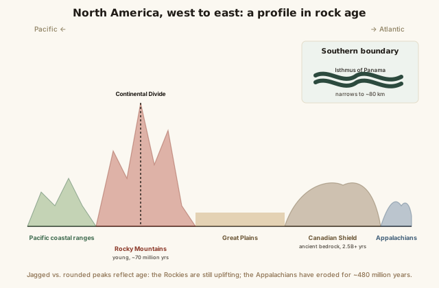
Scan the diagram left to right and the pattern is a rough timeline in rock: young, sharp terrain in the west gives way to the ancient, worn-smooth Canadian Shield at the core, then to the old, rounded Appalachians in the east — three very different ages of geology sitting on one continent. The narrow Isthmus of Panama at the bottom is the entire conventional link to South America, a corridor so narrow it's also the site of the Panama Canal.
Common mistakes
Common Mistakes
Thinking North America only includes the United States and Canada.
→ Conventionally, North America extends south through Mexico and all of Central America to the Isthmus of Panama — Mexico and the Central American countries are part of the same continent, not a separate one.
Assuming all of North America's mountain ranges are roughly the same age.
→ The Rocky Mountains (around 70 million years, still uplifting) and the Appalachian Mountains (around 480 million years, heavily eroded) differ in age by hundreds of millions of years, which is why they look so different.
Treating a mountain's official elevation as a permanently fixed number.
→ Official elevations are periodically revised as survey technology improves — Denali's official height changed by 10 feet in 2015 due to better GPS measurement, not because the mountain changed.
Common misconception
“North America is just the United States and Canada — Mexico and Central America belong to a separate region.”
By standard geographic convention, North America extends all the way from the Arctic islands of Canada down through the United States, Mexico, and every Central American country to the Isthmus of Panama. Mexico and Central America are not a separate continent or a transitional "in-between" zone — they sit on the North American tectonic plate and are part of the same continent as the US and Canada. "Central America" is a cultural and regional subdivision within North America, similar to how "Southeast Asia" is a subregion within Asia, not a separate continent of its own.
Is Mexico part of North America or a separate continent?
Try it yourself
What to do next
What to do next
- Trace the Continental Divide along the Rocky Mountains on a map and pick two nearby points on either side — notice how far apart their rivers end up flowing.
- Compare the Rockies and the Appalachians on a relief map and connect their visual difference (jagged vs. rounded) to their roughly 400-million-year age gap.
- Use the calculator above to estimate driving time across a stretch of North America you're curious about.
- Read the related entry on Geography of South America to see what's on the other side of the Isthmus of Panama.